

⚡ Resilience vs. Risk: Understanding AB 303 and the Future of Battery Storage in California
Battery storage is key to California’s clean energy future—but incidents like the Moss Landing fires highlight the risks. AB 303 and spatial analysis offer a path to safer, smarter siting.

An aerial view of Moss Landing, California—site of multiple battery energy storage system (BESS) fires. Spatial analysis tools can help balance clean energy deployment with environmental protection, public safety, and community input by identifying low-conflict sites, visualizing hazard zones, and informing smarter, data-driven siting decisions. The community of Moss Landing (lower left), Elkhorn Slough National Estuary (center-right), Moss Landing Wildlife Area (center-top) and Moss Landing Power Plant (lower left) - the site of the recent fire at the Vistra Battery Energy Storage System facility.
🔋 Why Battery Energy Storage Systems (BESS) Matter
Battery Energy Storage Systems (BESS) are critical infrastructure in California’s transition to a clean, resilient grid. These facilities store surplus solar and wind power and dispatch it during periods of high demand, reducing strain on the grid and reliance on fossil-fuel peaker plants.
From 2018 to 2024, California increased BESS capacity by over 3,100%, becoming a national leader in grid-scale energy storage. But recent high-profile safety incidents have exposed a dangerous gap in the regulatory framework—and reignited local resistance to centralized siting authority.
🧯 What Prompted AB 303?
The Battery Energy Safety and Accountability Act (AB 303) was introduced by Assemblymember Dawn Addis in 2025 following a fire at the Vistra Energy facility in Moss Landing, which burned for six days. The incident forced the evacuation of 1,500 residents, shut down Highway 1, and released toxic heavy metals into a nearby estuary—home to endangered sea otters.
This was not an isolated event. California experienced at least ten major BESS-related incidents in five years. Fires at lithium-ion facilities in Escondido, San Diego also triggered evacuations, air quality warnings, and long-term environmental concerns.
These disasters have raised urgent questions:
Where should BESS be sited?
Who decides—the state or local governments?
Can we safely expand BESS fast enough to meet climate goals?
🏛️ What AB 303 Would Change
As currently written, AB 303 would apply to BESS facilities storing 200 megawatt-hours (MWh) or more and would make the following changes:
Restrict siting on "Environmentally Sensitive Sites" such as:
Prime farmland and wetlands
Very high fire hazard zones
Endangered species habitats
Coastal areas subject to sea-level rise
Conservation lands and easements
Prohibit development within 3,200 feet of “Sensitive Receptors,” including:
Residences and schools
Parks and health care facilities
Community centers and public-facing businesses
Revoke eligibility for CEC’s Opt-In Certification Program under AB 205 (2022), thereby removing the streamlined permitting process for BESS while keeping it intact for other renewable technologies.
Immediately deny all pending applications for BESS currently under CEC review as of the bill’s effective date.
🧩 The Policy Debate: State Efficiency vs. Local Accountability
AB 303 brings to the forefront a longstanding policy debate: Should local communities have greater say in the siting of energy infrastructure, or should the state retain centralized authority to meet climate mandates?
Statewide Control: Efficiency and Scale
Since 2010, the California Public Utilities Commission (CPUC) and California Energy Commission (CEC) have led state efforts to integrate BESS. Their centralized authority is designed to:
Streamline permitting via CEQA exemptions
Ensure technical standards are met across all projects
Promote rapid deployment to meet climate targets
EvEco analysis acknowledges this centralization supports efficient scaling and consistent safety enforcement. However, it risks marginalizing local voices and downplaying site-specific environmental and cultural impacts.
Local Control: Equity and Environmental Justice
Supporters of AB 303 argue that local communities bear the brunt of BESS externalities, such as toxic exposure, land use conflicts, and ecosystem degradation. They contend that:
Local permitting enhances environmental review quality
Tribes and rural communities can assert cultural and land-use priorities
Diverse stakeholders—including environmental NGOs, youth centers, and public health advocates—can participate meaningfully in decision-making
Yet, as analysts caution, most local governments lack the engineering capacity to evaluate modern battery technologies. A patchwork of local ordinances could also delay or deter essential projects, undermining California’s decarbonization goals.
🗺️ How Spatial Analysis Can Help
Whether AB 303 passes or not, advanced spatial analysis tools offer a path to reconcile safety, equity, and energy resilience.
Geospatial technology offers a path forward. By integrating data on land use, environmental sensitivity, infrastructure, and population density, spatial analysis can help:
Identify Low-Conflict Zones: Pinpoint locations suitable for BESS with minimal exposure to environmental risk or community opposition, through GIS mapping of hazards, sensitive receptors, and infrastructure.
Model Safety Buffers: Simulate hazard zones (e.g., fire, flood, seismic) to test potential setbacks and emergency response implications, Visualizing 3,200-foot buffers around schools, homes, and ecological assets.
Modeling cumulative impacts: Provide meaningful assessment of the benefits and impacts of multiple projects in a single region and in context with statewide energy capacity.
Improve Transparency: Share spatial data with the public and decision-makers to facilitate informed, equitable site planning, supporting transparent public engagement through open data platforms.
Streamline Permitting: Enable state and local agencies to coordinate through shared spatial platforms, reducing redundant reviews and permitting bottlenecks.
For regulators and project proponents alike, spatial planning tools provide a way to bridge the gap between environmental protection, community input, and technological progress. Spatial analysis empowers both regulators and developers to proactively address concerns—making clean energy projects faster, safer, and fairer.
🧠 Policy Recommendation: Balance Safety with Speed
EvEco analysis concludes that a hybrid model—with state regulation of safety and local authority over siting—could be the most effective path forward. This approach would:
Preserve technical consistency in safety standards
Uphold local control where environmental justice is most at stake
Allow strategic use of the CEC’s Opt-In Program under clearer guidelines
Alternatively, AB 303 could be amended to require state-led safety oversight while improving local consultation, rather than excluding BESS from streamlined permitting entirely.
🔮 Conclusion: Responsible Deployment Is Key
As California leads the nation in climate action, BESS will be central to ensuring grid reliability and renewable energy integration. But resilience cannot come at the expense of community safety, environmental justice, or public participation.
With better data, stronger collaboration, and smart policy tools like spatial analysis, the state can move beyond false choices—and build the energy future Californians deserve.
AB 303 reflects growing public demand for safety and accountability in energy infrastructure. While its restrictive provisions may challenge project timelines, it also opens the door for more collaborative, data-informed siting practices.
If paired with accelerated development of state safety standards and a coordinated approach to spatial planning, AB 303 could evolve from a brake on progress to a blueprint for responsible, resilient energy development.
📌 Additional Resources
✉️ Want help evaluating BESS sites or mapping siting constraints?
Contact us at connect@evecogeo.com or schedule a consultation.

🔍Groundwater Resilience in the Face of Climate Change: A Look at the Eagle Lake Basin
Groundwater sustainability is the key to water resources resilience in the face of climate change.
The Eagle Lake Basin in Northeastern California is a high-desert watershed where alpine meadows, volcanic uplands, and sagebrush landscapes converge. Beneath this scenic landscape lies a critical, often overlooked resource: groundwater. As climate change shifts precipitation patterns, snowpack dynamics, and surface water availability across the West, the resilience of this groundwater—and the communities and ecosystems that depend on it—faces growing uncertainty.
We recently applied the USGS Basin Characterization Model (BCM) to investigate how climate change might impact groundwater recharge in the Eagle Lake Basin. What we found underscores the importance of integrating geospatial technology and climate science into long-term water management strategies for rural and resource-dependent communities.
🌄 Why Eagle Lake Matters?
Eagle Lake is a desert-terminal lake, fed primarily by Pine Creek and surrounded by federal lands, working forests, ranches, and small tribal and residential communities. While the area remains largely undeveloped, groundwater supports nearly 100% of the basin’s community and domestic water use, as well as agricultural operations critical to the local economy.
Although the region is not currently designated as a high-priority basin under California’s Sustainable Groundwater Management Act (SGMA), its groundwater-reliant beneficial uses—municipal supply and agriculture—are vulnerable to long-term climate shifts.
Past conditions...
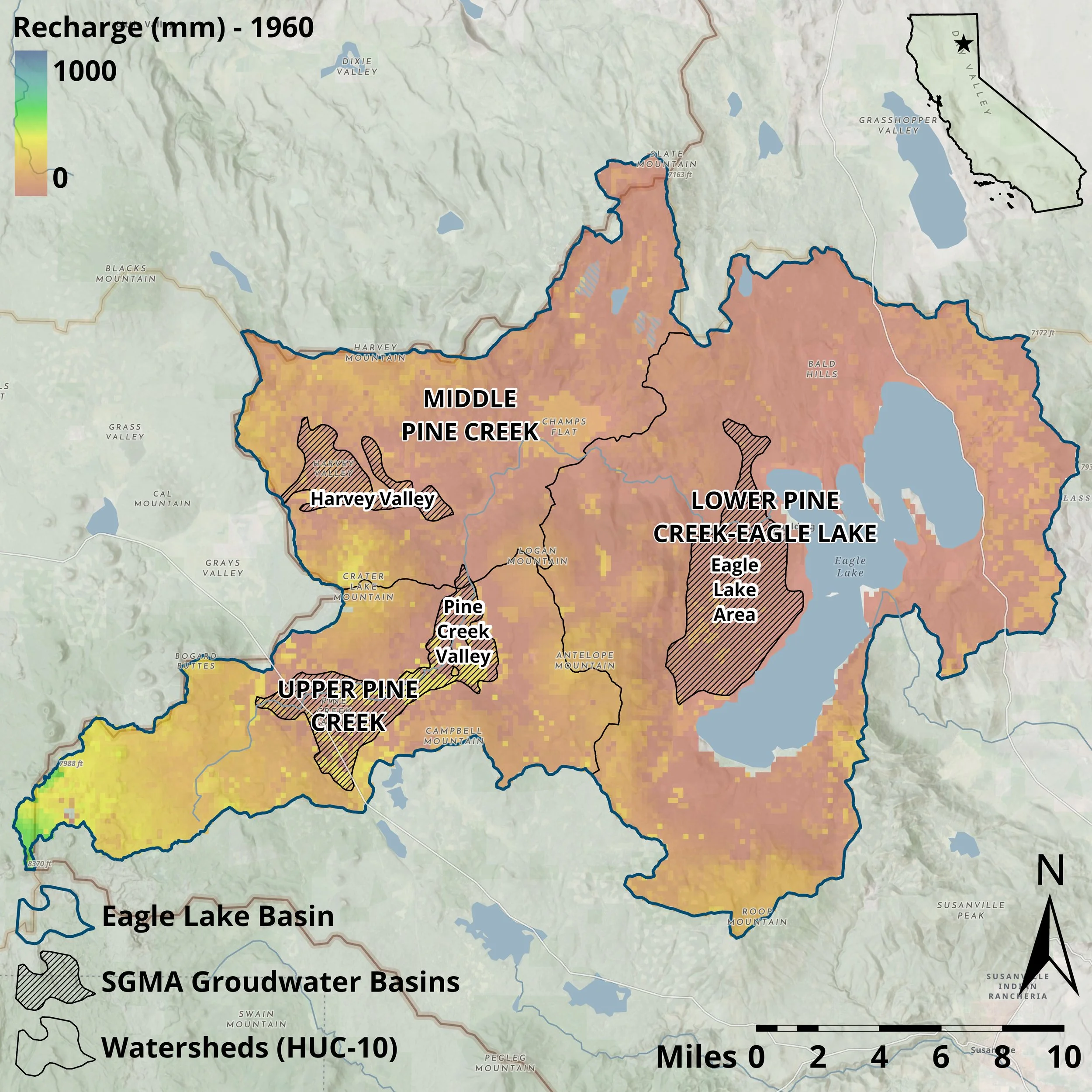
Mean Annual Recharge (mm) for the water year 1960 for the watersheds of the Eagle Lake Basin.
Groundwater recharge capacity was historically more diffuse across the landscape, supported in part by the combined effect of greater average annual precipitation falling as snowpack together with cooler average temperatures over the course of the year, allowing for percolation into the porous volcanic geologic formations and quaternary deposits in the meadows of the Eagle Lake Basin.
Future recharge…
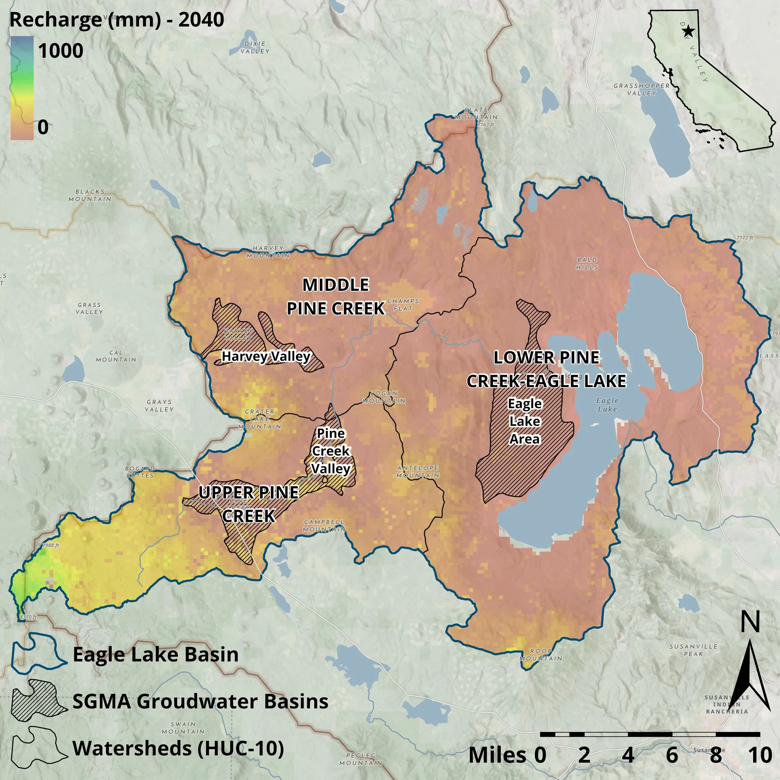
Mean Annual Recharge (mm) for the water year 2040 for the watersheds of the Eagle Lake Basin.
Groundwater recharge capacity can be predicted to be less distributed across the landscape, concentrating in the high elevations of the Pine Creek Watershed headwaters in the southeastern portion of the Eagle Lake Basin near Lassen Volcanic National Park and the Caribou Wilderness.
📊 What Climate Models Tell Us
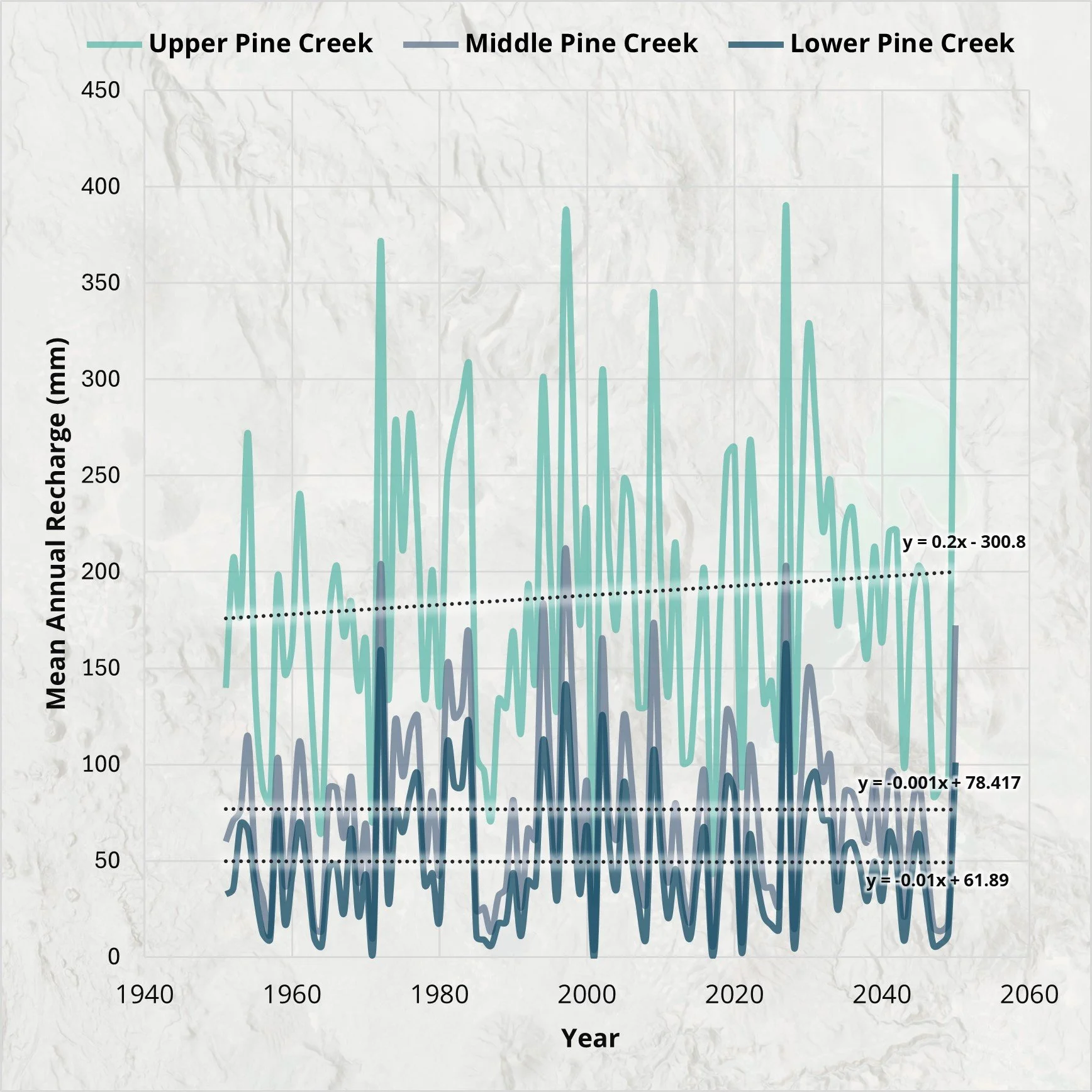
Using the BCMv8 model and LOCA-downscaled climate projections (RCP 4.5 scenario), we simulated potential changes in groundwater recharge through the mid-21st century.
Key findings:
Upper Pine Creek Watershed, characterized by volcanic geology and expansive meadows, remains the primary recharge zone. This area is critical to future groundwater resilience.
Recharge capacity in lower and more arid areas is projected to decline or stabilize, meaning higher-elevation recharge zones will bear more responsibility for sustaining the basin’s aquifers.
Seasonal snowpack—already declining—is expected to peak earlier and contribute less to spring runoff, reducing opportunities for deep infiltration and recharge.
🛠️ Implications for Water and Land Management
While some uncertainty remains, the modeling reveals actionable insights:
✅ Identify and protect high-recharge areas in upper watershed zones.
🌱 Promote land management practices that enhance infiltration, such as wet meadow restoration and controlled grazing.
💧 Prepare communities for shifts in water availability through conservation, reuse, and decentralized water strategies.
Most importantly, this research highlights the need for a “Total Water Management” approach that recognizes the full hydrologic cycle—from snowpack to soil moisture to groundwater discharge—as interconnected. Community water planning must account not only for present-day demands but also for long-term groundwater viability under changing climatic conditions.
🔄 Next Steps: From Modeling to Management
This work is just the beginning. Future research should:
📈 Incorporate multiple emissions scenarios and hydrologic variables (e.g., discharge, soil moisture, evapotranspiration).
🌦️ Support the development of a basin-scale water budget to guide planning.
🧑🤝🧑 Engage local landowners, agencies, and tribal governments in developing a shared vision for groundwater resilience.
For small and rural communities in California and beyond, the time to act is now. By pairing geospatial modeling tools with locally grounded planning, we can build lasting strategies for climate adaptation and natural resource stewardship.
📌 EvEco, L.L.C. helps communities integrate geospatial science into decision-making for resilient infrastructure, environmental protection, and sustainable growth. Learn more at evecogeo.com.
Flint, L.E., Flint, A.L., and Stern, M.A., 2021, The basin characterization model—A regional water balance software package: U.S. Geological Survey Techniques and Methods 6–H1, 85 p., https://doi.org/10.3133/ tm6H1.
Stern, M.A., Flint, L.E., Flint, A.L., and Seymour, W.A., 2024, Future Climate and Hydrology from Twenty Localized Constructed Analog (LOCA) Scenarios and the Basin Characterization Model (BCMv8): U.S. Geological Survey data release, https://doi.org/10.5066/P9K23J25.
O'Connor, T., D. Rodrigo, AND A. Cannan. Total Water Management: The New Paradigm for Urban Water Resources Planning. In Proceedings, World Environmental & Water Resources Congress 2010, Challenges of Change, Providence, RI, May 16 - 20, 2010. Environmental & Water Resources Institute (EWRI) of ASCE, Reston, VA, 3251, (2010).